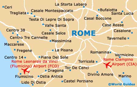
Rome Leonardo da Vinci Fiumicino Airport (FCO)
Orientation and Maps
(Rome, Italy)
Rome is one of Italy's most popular and historic cities, being full of life and energy. With many world-famous ruins and ancient monuments dating back more than 1,000 years, a visit to Rome is always a memorable one.
Home to two separate airports, Rome Fiumicino Airport (FCO) is the city's main airport and is often known locally as the 'Aeroporto Leonardo da Vinci'. Located on the south-western side of Rome, Fiumicino Airport is actually the biggest airport in the whole of Italy and responsible for transporting around 30 million passengers each year.
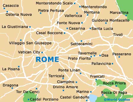
Areas of interest close to Rome include Fonte Nuova and Monterotondo to the north, Ciampino to the south-east, and both Cerveteri and Ladispoli to the west. Further afield, Naples (Napoli) can be reached in around two and a half hours, being approximately 225 km / 140 miles to the south-west of Rome.
Rome Fiumicino Airport (Leonardo da Vinci) (FCO) Maps: Important City Districts
The very centre of Rome is divided into distinct districts, with a maze of streets in the 'centro storico' block, alongside the winding River Tiber. From this area, Rome spreads out in all directions and to the east you will find a high concentration of shops, close to the Via del Corso and the famous Spanish Steps. The main thoroughfare in this part of Rome is the Via Nazionale.
Many of the main landmarks and famous monuments lie to the south of central Rome, while the spreading park of Villa Borghese stands to the north. To the left of the River Tiber, the Vatican City is the official home of the pope and contains many spectacular buildings, including Saint Peter's Basilica.
Italy Map

Rome Map